
'%3E%3Cg transform='matrix(16 0 0 16 -1647.5 -1531.2)' fill='none' stroke='%231d294f' stroke-linecap='round' stroke-linejoin='round' stroke-width='.5'%3E%3Cpath d='m121.98 127.76c-0.17689-0.25929-0.43221-0.47949-0.52086-0.82074-0.0804-0.3665-0.21074-0.59019-0.42616-0.72606l-8.3969-6.566c-0.80889-1.592-0.36001-1.8363-0.0316-2.2097l10.67 9.5964-9.5333-12.564c-1.143 0.67661-1.1798 1.8274-1.168 2.9989'/%3E%3Cpath d='m113.8 114.53c-0.24523-1.7095 0.43356-2.0329 1.3574-1.9887l8.2391 14.679'/%3E%3Cpath d='m115.13 112.45c0.29977-1.4292 1.091-2.1507 2.0519-1.9256 0.55822-0.76427 0.91952-1.7369 2.5885-1.3258 0.85906-0.79567 1.7166-1.5981 2.9042-0.91545'/%3E%3Cpath d='m122.54 108.28c1.1781-0.59147 2.1673-0.64808 2.8411 0.1894 1.2493-0.0237 2.6335-0.13253 2.336 0.82075 1.0406 0.20401 2.4264-0.0236 2.5254 1.3574 1.6748 0.51499 1.8097 1.107 1.8309 1.7046 1.5457 1.2255 1.8151 2.0449 1.5152 2.6832 1.479 1.198 0.62595 1.6187 0.75762 2.3676 0.11915 0.9679 0.21187 1.8962 0 2.3675-0.81373 1.3061-3.4159 2.4942-4.8929 3.5355l-3.7249 2.8726c-0.244 0.2787-0.22631 0.59711-0.31569 0.91551 0 0.0105 0.0149 0.71068 8e-3 0.30781'/%3E%3Cpath d='m117.15 110.62 6.345 16.557-3.6934-17.946'/%3E%3Cpath d='m122.51 108.31 0.91545 18.735 1.7678-18.735'/%3E%3Cpath d='m127.78 109.16-4.4194 17.962 6.8817-16.462'/%3E%3Cpath d='m132.05 112.16-8.6021 14.994 10.18-12.217'/%3E%3Cpath d='m134.22 117.5-10.875 9.5807'/%3E%3Cpath d='m119.94 125.37c-0.0426 1.3351 0.83865 2.0798 1.7836 2.5096 1.3187 0.15538 2.4687 0.0857 3.5355-0.0947 2.0017-0.44463 2.1106-1.7517 2.1308-2.8568'/%3E%3C/g%3E%3C/g%3E%3C/svg%3E%0A) Seafood Safety
Seafood SafetyOnline Tools
VIBRIO RISK AND PHYLOGENY TOOLS
In partnership with the FAO the Reference Centre is aiming to develop a number of online tools which will help the international community monitor the risk of contamination of bivalve molluscs with Vibrio spp..
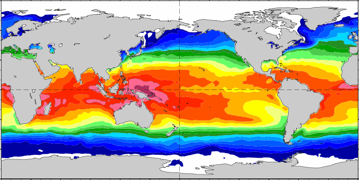
The Vibrio Map Viewer, developed in collaboration with the European Centre for Disease Prevention and Control (ECDC) and others, is a near real-time model that uses daily updated remote sensing data to examine worldwide environmental conditions, such as sea surface temperature and salinity for Vibrio spp.. The model used for the Vibrio Map Viewer has been calibrated to the Baltic Region in Northern Europe and might not apply to other worldwide settings prior to validation. The Vibrio Map Viewer is also one of a range of oceanographic data visualisation tools available from the US National Oceanic and Atmospheric Administration (NOAA) as part of its Ocean Viewer platform (select Vibrio Risk from the menu then choose either Daily, Cumulative or Forecast Vibrio Risk).
The Vibrio parahaemolyticus global phylogeny tool, using the Microreact application, shows the phylogenetic relationships, geographic distribution and timeline of a collection of more than 1300 V. parahaemolyticus genomes. The collection comprises genomes available from public databases (NCBI) along with genomes from strains deposited in the Reference Centre's V. parahaemolyticus global culture collection, covering particularly areas of the world underrepresented in the public databases. NOTE: this tool may not work with Microsoft web browsers and is best viewed using Chrome, Firefox or Safari.
CLASSIFICATION PROGRAMME TOOLS
There are numerous examples of specialist open source, free to use, software available online to aid the establishing and running of classification programmes.
For mapping and geospatial data analysis, QGIS is one of the most well-known and is best summed up by the OS Geo organisation:
"QGIS is the leading Free and Open Source Desktop GIS. It allows you to create, edit, visualise, analyse and publish geospatial information on Windows, Mac OS, Linux, BSD and Android (via the QField app)."
QGIS is available to download here and can be used to aid classification programmes in the following ways:
- Planning of sanitary surveys
- Creation of professional maps for bivalve classification zones - if necessary these can then be displayed online via HTML interactive web maps
- Visualisation to allow geospatial analysis on sources of contamination
- Integrated use of the QField app to capture geospatial data in the field and export to QGIS projects
- Use of a multitude of plugins to extend functionality, such as direct import of Sentinel satellite imagery into QGIS via the Sentinel Hub plugin
There is a wide range of training resources for QGIS available in a multitude of languages and formats, for example the official QGIS community provides training manuals in English, French, Spanish and Portuguese.
The running of a bivalve classification monitoring programme generates a substantial amount of data and this should ideally be stored in a secure database. ‘Relational’ databases are generally used for this purpose as they offer several advantages:
- Data Integrity: Relationships between tables reduce redundancy and maintain consistency.
- Ease of Use: SQL simplifies data retrieval and transformation, making relational databases accessible to non-technical users.
- Scalability: Modern relational databases support cloud-based scaling and advanced features like read replicas for disaster recovery.
- Backup and Recovery: Built-in tools allow for seamless data export, import, and mirroring.
The ability to conduct analysis over long term data sets is critical to the management of a successful programme.
It is advantageous for the database to be able to conduct geospatial analysis on submitted results, such as determining the distance a sample was collected from the designated location of a representative monitoring point.
PostgreSQL is a free, open source, relational database builder that enables databases to be created. PostgreSQL is available to download here. PostGIS extends the functionality of PostgreSQL by adding geospatial analysis capabilities. PostGIS is available to download here.
As with QGIS there is a range of learning materials available in different languages and formats to support users of this software. The following training resources are provided by the PostgreSQL and PostGIS official community:
- PostgreSQL documentation in English, French and Brazilian Portuguese
- PostgreSQL training in English
- PostGIS documentation in English
- PostGIS training in several languages including English and Spanish
Further considerations and recommendations on the implementation of GIS software and databases can be found in the Technical guidance for the Development of the Growing Area Aspects of Bivalve Mollusc Sanitation Programmes.